



A typical professional residential land survey costs roughly $200 to $1,200, with an average near $546. The survey type and property complexity can push the total far higher, especially when the work involves elevation data, difficult terrain, missing records, or a signed deliverable for construction or legal use.
ze](#real-price-examples-by-property-size)
- Typical land survey costs by type and parcel size
- Why the acreage comparison can mislead
- Records can add work before the crew arrives
- Rush service changes the schedule and the price
- Direct wages aren't the same as the project fee
- Separate fixed and variable components
- Use a scope checklist when comparing bids
The Quick Answer on Land Survey Costs
Recent consumer cost data places a typical professional land survey at approximately $200 to $1,200, with an average near $546. Treat that figure as a starting benchmark for a straightforward residential assignment, not as a guaranteed quote for your parcel.Residential benchmark: A standard survey often costs several hundred dollars, but the final price depends on the survey type, parcel conditions, available records, site access, and required deliverables.
Broader estimates across different survey assignments extend from approximately $475 to $25,000, according to the professional surveyor pricing discussion published by the U.S. Bureau of Labor Statistics. The range reflects very different scopes, including boundary work, topographic mapping, ALTA/NSPS surveys, construction staking, and subdivision work.
The acreage alone does not explain the quote. A small lot with buried corners, conflicting deed descriptions, dense vegetation, or difficult access can take more office and field time than a larger, open parcel with clear records. Two surveyors can price the same property thousands of dollars apart because one includes monument placement, records research, filing, and a signed and sealed final plat while the other prices only limited fieldwork.
The deliverables stack determines whether a low quote is useful. Ask whether the proposal covers deed and plat research, monument recovery or setting, boundary analysis, measurements, drafting, revisions, filing, and the final document required by your lender, permit office, contractor, or attorney. A quote that excludes one of these items may look cheaper while leaving you to pay for the missing work later.
For initial benchmarks, use this guide to compare land survey prices. Online ranges help screen proposals, but they cannot establish a fair price without a written scope.
Compare quotes by asking:
The practical goal is a complete, legally usable scope. Choose the quote that makes the work and final deliverable clear, not just the lowest dollar amount.
Survey Types and What Each One Actually Costs
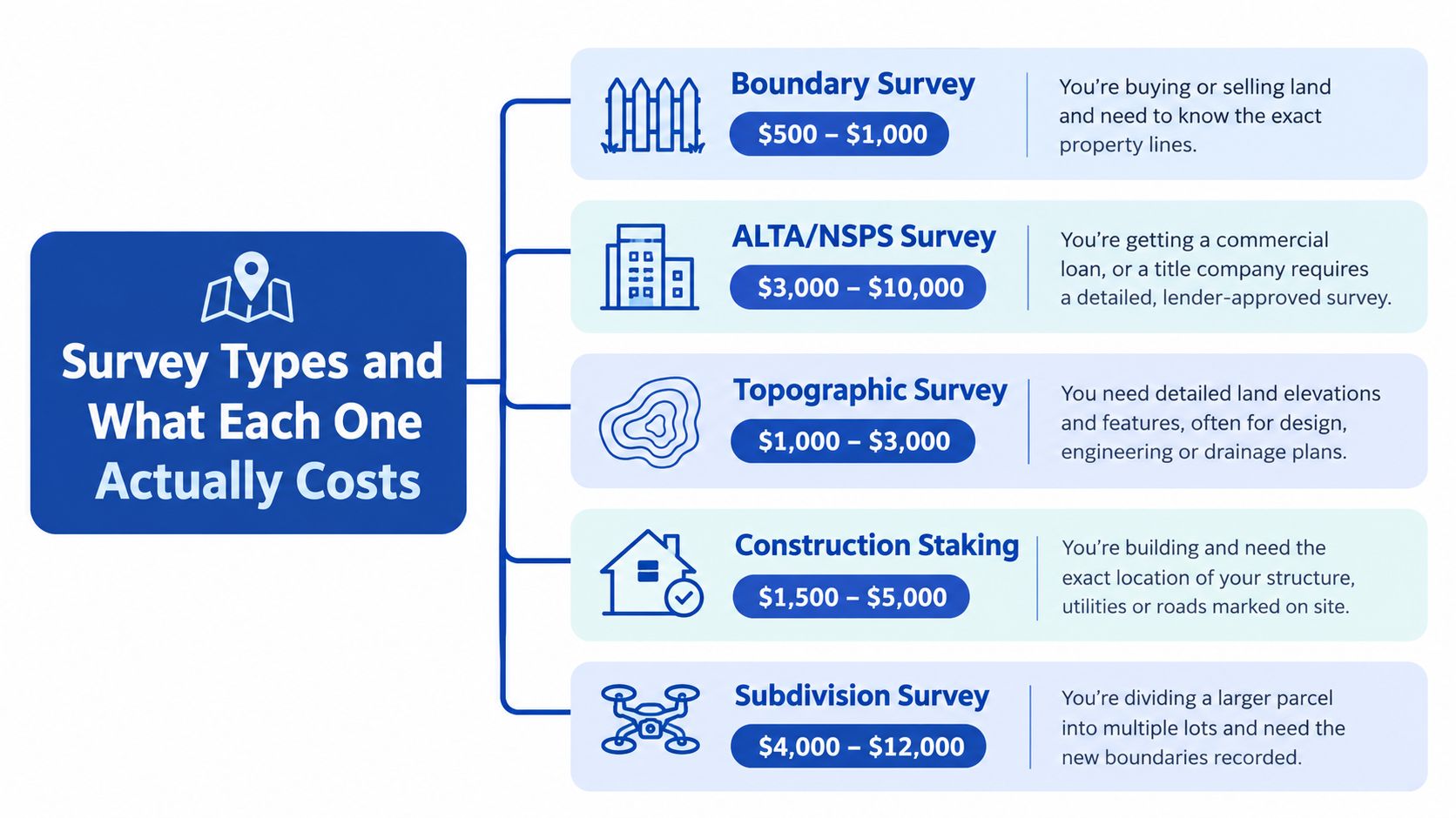
The survey type determines the evidence the surveyor must recover, the measurements collected, and the document delivered. A boundary survey addresses property lines. A topographic survey addresses terrain and elevation. An ALTA/NSPS survey supports a more demanding commercial title decision. Comparing quotes by these deliverables, rather than by the total alone, explains why two surveys on the same lot can have very different prices.
Boundary surveys locate the legal lines
A homeowner may order a boundary survey before building a fence, checking a possible encroachment, buying property, or resolving a disagreement with a neighbor. The surveyor researches the deed, subdivision plat, adjoining descriptions, and available prior records. The field crew then searches for existing monuments, measures relevant corners and lines, and analyzes whether physical evidence agrees with the written record.
The final package may include a plat, identified or set monuments, visible improvements, easements, and a signed survey prepared under the surveyor's professional responsibility. Residential pricing benchmarks place this work roughly in the $1,200 to $5,500 range. The fair quote is the one that states whether research, monument recovery or setting, drafting, revisions, and the signed final document are included.
ALTA/NSPS surveys serve title and commercial decisions
An ALTA/NSPS survey is normally requested for a commercial closing, financing, or title-insurance review. It requires more than locating a few corners. The surveyor may examine title materials, plot easements and exceptions, locate improvements, identify access conditions, and complete selected Table A items.
The price rises because the deliverable must include the agreed Table A items, easement plotting, improvement locations, and title review. Those tasks are not part of every standard boundary plat. The scope should be confirmed by the lender, title company, attorney, and surveyor before fieldwork begins.
If the reference systems and control points used in surveying are unfamiliar, this explanation of a base line in INTELLI surveying provides useful technical context. It does not replace the project-specific instructions in the survey proposal.
Topographic surveys map elevation and site features
A topographic survey is used before grading, drainage design, site planning, roadway work, or construction on sloped land. The crew collects elevations and maps terrain changes, structures, visible utilities, drainage features, trees, pavement, and other requested improvements. The price reflects the area surveyed, the density of elevation shots, the required accuracy, and the number of features shown.
A topographic quote should state the coverage area, benchmark or coordinate requirements, contour or elevation detail, and whether the deliverable includes CAD files and a sealed plan. Compared with a boundary survey, the client is paying for a denser record of site conditions that designers and contractors can use. A low quote may cover only selected spot elevations and omit the features needed for design.
Mortgage surveys and construction staking answer narrower questions
A mortgage survey, sometimes marketed under another local name, is generally ordered for a lender's property review. It may provide less detail than a boundary survey. Confirm whether it locates legal corners, shows improvements, and provides a signed document acceptable for the transaction.
A stake-out or construction-staking survey transfers design information from plans to the ground. The surveyor may stake building corners, excavation limits, grades, utilities, foundations, or other points. Pricing depends on the number of points, required accuracy, plan complexity, and the contractor's required site visits. A stake-out does not replace boundary research when the project depends on knowing the legal property line.
Real Price Examples by Property Size
Acreage helps establish scale, but it doesn't determine the entire fee. The clearest examples come from straightforward parcels with reasonably clear deeds and uncomplicated access. A parcel with the same acreage can cost much more when its corners are missing, its boundaries are irregular, or the client needs more than a basic boundary plat.
For a smaller residential parcel of one-half acre or less, one industry cost analysis reports a typical range of $400 to $1,000, with an average of about $600. These figures generally describe uncomplicated boundary work, not a complete topographic or construction package.
A one-acre boundary survey may fall around $500 to $1,000 in one published estimate. Larger tracts illustrate why surveyors sometimes quote by acreage. An 80-acre survey may be priced at roughly $75 per acre, while a 100-acre survey may be about $65 per acre. The lower per-acre figure doesn't mean the surveyor is doing less careful work. Mobilization, setup, research, and drafting are spread across a larger area, while the field pattern can become more efficient.
Typical land survey costs by type and parcel size
| Survey Type / Parcel | Typical Range | Average |
|---|---|---|
| Residential parcel of one-half acre or less | $400–$1,000 | About $600 |
| One-acre boundary survey | $500–$1,000 | Not specified |
| 80-acre survey | About $75 per acre | Not specified |
| 100-acre survey | About $65 per acre | Not specified |
| Professional land survey, broad residential benchmark | $200–$1,200 | About $546 |
The figures in the table are benchmarks, not universal national fees. The residential figures assume relatively straightforward boundary work, often on lots of one-half acre or less with reasonably clear deeds. The larger-parcel examples illustrate a pricing method, not a guaranteed rate for rural or agricultural land.
Why the acreage comparison can mislead
A square parcel with four clear corners may be efficient to survey. An irregular parcel of the same area may contain more corners, longer boundary footage, inaccessible lines, and conflicting evidence. A surveyor must resolve those conditions whether the property is small or large.
Ask whether the quote is based on the entire parcel or only a defined boundary segment. Also confirm whether the price includes research, field measurements, corner recovery, new monument placement, drafting, filing, travel, and the final signed document. Two bids can look far apart because one includes the full deliverables stack and the other prices only the initial field visit.
What Drives the Price of Your Survey
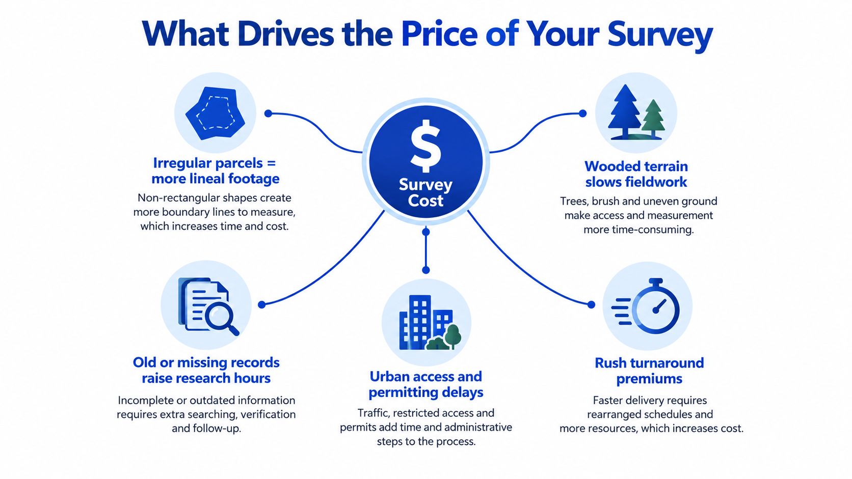
The strongest cost drivers are scope, boundary complexity, terrain, records, access, and urgency. Acreage matters, but it is a weak predictor when considered by itself.
An irregular parcel requires more lineal boundary footage to measure and more corners or changes in direction to analyze. A survey crew may also need to resolve competing evidence, such as an old monument that doesn't align neatly with a deed description or a fence that doesn't follow the documented line.
Terrain changes the fieldwork in practical ways. Wooded land can block sight lines and hide monuments. Steep ground increases walking time and safety demands. Snow-covered ground can conceal markers, while poor road access adds mobilization and equipment challenges. These conditions don't just make the job less convenient. They increase the time required to collect and verify reliable evidence.
Records can add work before the crew arrives
A surveyor may need to review courthouse records, title materials, subdivision plats, adjoining deeds, and prior surveys before fieldwork begins. Missing or inconsistent records require more professional judgment and evidence recovery. Monument searches can also take time, especially when corners are covered by driveways, landscaping, structures, or accumulated soil.
Urban properties introduce a different set of obstacles. Dense improvements, limited parking, restricted access, traffic, and permitting requirements can slow mobilization. If your work involves a permit or an addition, review the applicable building permit requirements before requesting the survey so the surveyor can include the information your authority expects.
Rush service changes the schedule and the price
Expedited delivery can nearly double pricing because the firm may need to rearrange scheduled crews, prioritize your records research, and move drafting and professional review ahead of other projects. A rush request also increases the risk that a client confuses a fast preliminary sketch with the final signed survey.
Practical rule: Give the surveyor the required completion date before accepting a quote. A normal schedule and an emergency schedule are different services.
A five-acre square parcel with clean records can cost less than a one-acre property with disputed corners and heavy vegetation. That comparison captures the central pricing principle. Surveyors charge for the work needed to reach a defensible result, not just for the number printed beside “acreage.”
What Happens on Site and What You Are Paying For
A survey invoice represents a labor-and-deliverables stack. The field visit is only one part of the job, and often not the part that carries the most professional responsibility.
Before arriving, the surveyor may perform courthouse or title-record research, review deeds and plats, study adjoining descriptions, and search for prior surveys. The crew then mobilizes to the site, establishes control points, searches for monuments, measures boundaries or improvements, and records evidence that may affect the final analysis.
After fieldwork, the office team processes measurements, prepares CAD drawings, checks the boundary solution, drafts the plat, and submits the work for licensed-surveyor review. The scope may also include setting or identifying monuments, preparing a sealed plan, filing documents, answering revisions, or providing digital files.
Direct wages aren't the same as the project fee
The U.S. Bureau of Labor Statistics reports a 2025 median surveyor wage of $75,440 annually, equivalent to $36.27 per hour before employer overhead, vehicles, equipment, software, insurance, drafting, quality control, and professional liability costs. That figure is cited in the 2025 surveyor wage data.
A homeowner therefore shouldn't multiply an hourly wage by the time spent holding an instrument and assume that equals the project price. A professional firm must support the crew, maintain equipment, carry insurance, process data, pay technical staff, and have a licensed surveyor accept responsibility for the deliverable.
Separate fixed and variable components
A useful way to audit any quote is to separate work that exists on nearly every project from work that changes with the parcel:
| Fixed or mostly fixed work | Variable work |
|---|---|
| Mobilization and setup | Field hours |
| Records research | Travel distance |
| CAD drafting | Crew size |
| Certification and review | Vegetation and terrain |
| Basic project administration | Number of corners or stakes |
For construction, as-built, or topographic work, ask whether the final package includes a coordinate system or benchmark, spot elevations, breaklines, utilities, structures, digital CAD files, and a sealed plan. Those items determine whether the survey can support design, permitting, financing, or construction control.
The on-site visit itself may be brief on an open lot and much more involved on a difficult property. Turnaround depends on the records, field conditions, queue at the firm, and review requirements. Get the promised delivery date in writing rather than assuming the field visit means the final survey is complete.
How to Get Accurate Quotes and Save Money
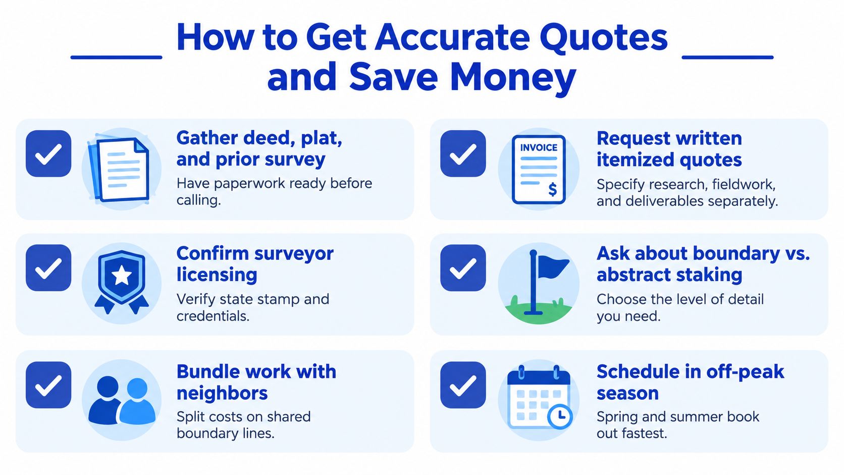
The best quote request gives the surveyor enough information to price the actual job. Send the street address, parcel identification if available, deed, recorded plat, prior survey, title materials, project purpose, site plan, and deadline. A surveyor can often identify missing scope immediately when these documents arrive together.
Ask for a written, itemized quote. The document should identify the survey type, research included, fieldwork, corner recovery, monument placement, plat or map, filing requirements, travel, revisions, digital files, and turnaround time. If the quote uses a phrase such as “standard survey,” ask the firm to define exactly what that means.
Use a scope checklist when comparing bids
Put each firm's answer into the same comparison sheet:
For construction work, confirm whether the surveyor will provide the specific design control your contractor needs. A boundary plat may be perfectly appropriate for a fence and still be insufficient for grading or foundation layout.
You can reduce cost without reducing quality by supplying existing records, clearing access to known corners, coordinating a shared boundary project with neighbors, or scheduling outside the firm's busiest period. Bundling related work can also avoid duplicate mobilization when the surveyor will already be on site.
The wrong savings strategy is to remove a deliverable that protects the purpose of the survey. Skipping monument placement may leave you with a drawing but no visible points to guide the fence contractor. Omitting the signed final survey can create a document that a lender, permit office, or attorney won't accept.
For help organizing the broader hiring process, use this guide to find local contractors, then verify that the survey professional is properly licensed for the work in your jurisdiction.
Red Flags and the Questions to Ask Before You Hire
A reliable surveyor should explain the scope without hiding behind a single total. Ask these questions before authorizing the work:
A verbal-only price is a warning sign. So is a quote that refuses to itemize scope, says nothing about records research, or appears unusually low because it excludes the signed and sealed deliverable. The cheapest bid may be reasonable when the scopes match, but price alone can't show whether the survey will answer your actual question.
If a boundary disagreement could become a legal matter, understanding what to expect from a litigation attorney can help you recognize why a clear professional record matters. The surveyor isn't a substitute for legal advice, and an attorney isn't a substitute for a boundary survey. Each professional addresses a different part of the problem.
You can also review contractor license verification guidance before hiring anyone involved in the related construction work.
The single takeaway is simple: compare scopes, not just prices, and get every inclusion and exclusion in writing.
HomeProBadge helps homeowners evaluate home service professionals through verified identity, licensing, insurance, background information, reviews, and proof of completed work. Visit HomeProBadge to find qualified local pros and make the next step after your survey easier to verify.